New maps on Serious-Racing
Serious-Racing is growing, and we had to make some updates to our maps. We originally used Google Maps, because it was easy to set up and provided great-looking satellite images. Now we have a larger amount of users who are also more active, we decided to look for an alternative, so that we can keep Serious-Racing free.
When we first started out with Serious-Racing, Google Maps allowed us to provide great map functionality to our users. But now we have grown in popularity, we're getting close to reaching the limit of Google Maps' free usage. To ensure that we can scale to the number of users we expect (and use maps in more places than we currently are), we've decided to switch mapping providers.
Our choice has been to use the amazing OpenStreetMap along with Leaflet, a Javascript mapping library. It was relatively easy to switch, and with the nifty ColorFilter plugin we could get the colours of the map tiles to fit in with the rest of Serious-Racing. Overall, we are pretty happy with the look of the new maps. The upside is that we now can use maps on other pages, too. The Track Info pages for example; have a look at Spa.
The not so good news is that we won't have satellite images anymore.. As far as we know only satellite images show the actual outline of the track. Maps use a standard line thickness to indicate where roads are. The actual track might be wider or narrower than that. We are pretty sad about this and we can understand you might be, too. While we can't magically provide satellite images for free for everyone, we have set up our new mapping system so that we can easily switch between various types of maps. So perhaps – if people are interested – in the future we could provide a paid add-on that gives you back satellite images for users that really want them. Let us know what you think about that.
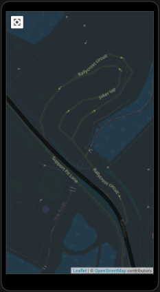
Now for something we actually think is pretty awesome with the new maps.. Quite a few tracks show up with the names of corners and straights indicated on the map! This is a pretty cool feature when you are preparing for a trackday on a new track. Since we now show a map on the track info pages, you can search for any track in our system, open a full screen map on your phone and see this level of information if it is available. And if your local track doesn't have named corners and straights yet, you can add them in yourself. If you are keen to improve the mapping information of any track in the world, go to the OpenStreetMap editing tutorial to learn how to add stuff to their maps. We certainly have already added some corners and straights to our favourite tracks and we will be adding a few more whenever we have a bit of spare time.
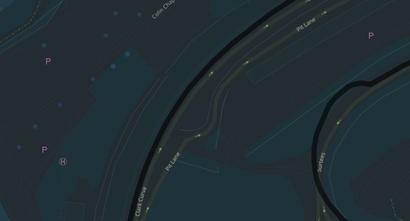
Detail of Brands Hatch with named straights and corners, pit lane. All images by © OpenStreetMap contributors
Although our articles are completely independent, some contain affiliate links. This means that, if the linked website has a product for sale and you buy that product, we get a referral fee from the seller. This doesn’t make the price of the product any higher for you as a buyer. Doing this allows us to offset some of the costs we have running Serious-Racing.
Sign up for free
What are you waiting for?
- Create a page for your car, bike, or kart
- Explore tracks
- Compare and analyse your laps
- Add video
- Share with friends
- Get faster